Württemberg/Staatshandbuch 1936/159: Unterschied zwischen den Versionen
Zur Navigation springen
Zur Suche springen
Keine Bearbeitungszusammenfassung |
Keine Bearbeitungszusammenfassung |
||
| (6 dazwischenliegende Versionen desselben Benutzers werden nicht angezeigt) | |||
| Zeile 1: | Zeile 1: | ||
<noinclude>{{Württemberg/Staatshandbuch 1936|158|167|160| | <noinclude>{{Württemberg/Staatshandbuch 1936|158|167|160|unkorrigiert}}</noinclude> | ||
{| class="wikitable" | {| class="wikitable" | ||
| Zeile 23: | Zeile 23: | ||
| style="width:15%"|10 | | style="width:15%"|10 | ||
|- | |- | ||
| ''' | | '''4.''' || '''Flacht''' (D.5) Pfd. || 689 || 676 || 2 || 9 || - || 2 || 4.1 || 25.1 || PAg (Bf 1 u. 22) <tt>409m</tt> | ||
|- | |- | ||
| || ''' | | | ||
|- | |||
| '''5.''' || '''Friolzheim''' (D.5) Pfd. m. M.G. || 742 || 710 || 1 || 27 || - || 4 || 5.1 || 25.1 || PAg (Bf 1) <tt>450m</tt> | |||
|- | |||
| | |||
|- | |- | ||
| || ''' | | '''6.''' || '''Gebersheim''' (D.4) Pfd. || 456 || 433 || 2 || 20 || - || 1 || 6.1 || 25.1 || PH TH (Bf P 1) <tt>412m</tt> | ||
|- | |- | ||
| | | | ||
|- | |- | ||
| ''' | | '''7.''' || '''Gerlingen''' (D.8) || 2671 || 2621 || 101 || 85 || 1 || 63 || || || | ||
|- | |||
| || '''1. Gerlingen,''' Pfd. || 2671 || 2438 || 71 || 80 || 1 || 51 || 7.1 || 5<ref name= Gerl7.1>Stadtkreis Stuttgart.</ref> || ZwPA ü. Stu. 5 (Bf 1 u. 2) <tt>336m</tt> | |||
|- | |||
| || 2. Bopser, Hsr. || 56 || 41 || 12 || - || - || 3 || 7.1 || 5<ref name= Gerl7.1/> || | |||
|- | |||
| || 3. Forchenrain, Hsr. || 28 || 21 || - || - || - || 7 || 7.1 || 5<ref name= Gerl7.1/> || | |||
|- | |||
| || 4. Gerlinger Heide, Hsr. || 4 || 4 || - || - || - || - || 7.1 || 5<ref name= Gerl7.1/> || | |||
|- | |||
| || 5. Laichle, Hsr. || 21 || 10 || 11 || - || - || - || 7.1 || 5<ref name= Gerl7.1/> || | |||
|- | |- | ||
| || | | || 6. Schillerhöhe, Hsr. || 67 || 58 || 3 || 4 || - || 2 || 7.1 || 5<ref name= Gerl7.1/> || | ||
|- | |- | ||
| || '''2. | | || '''2. Solitude,''' Staatsdomäne, Schl. u. Hsr. || 54 || 49 || 4 || 1 || - || - || 7.1 || 5<ref name= Gerl7.1/> || (P Stu.3) | ||
|- | |- | ||
| | | | ||
|- | |- | ||
| | | '''8.''' || '''Hausen an der Würm''' (D.4) || 344 || 330 || 14 || - || - || - || || || | ||
| | |- | ||
| || '''1. Hausen an der Würm,''' Pfd. || 331 || 323 || 8 || - || - || - || 8.1 || 25.1 || PSt ü. 25 (Bf 21) <tt>384m</tt> | |||
|- | |||
| || 2. Frohnmühle, Hs. || 7 || 7 || - || - || - || - || 8.1 || 25.1 || | |||
|- | |||
| || 3. Obere Sägmühle, Hs. || 6 || - || 6 || - || - || - || 8.1 || 25.1 || | |||
|- | |||
| | |||
|- | |||
| '''9.''' || '''Heimerdingen''' (D.5) || 875 || 862 || 4 || 9 || - || - || || || | |||
|- | |||
|- | |||
| || '''1. Heimerdingen,''' Pfd. || 869 || 858 || 4 || 7 || - || - || 9.1 || 18<ref name= Gerl7.1/> || Bf PAg <tt>408m</tt> | |||
|- | |||
| || 2. Haldenwaldmühle, Hs. || 6 || 4 || 4 || - || 2 || - || 9.1 || 18<ref name= Gerl7.1/> || | |||
|- | |||
| | |||
|- | |||
| '''10.''' || '''Heimsheim''' Stadt (D.6) || 1111 || 1073 || 8 || 30 || - || - || 10.1 || 25.1 || PAg (Bf 25) <tt>413m</tt> | |||
|- | |||
| | |||
|- | |||
| '''11.''' || '''Hemmingen''' (D.6) || 1004 || 949 || 30 || 20 || - || 5 || || || | |||
|- | |||
|- | |||
| || '''1. Hemmingen,''' Pfd. || 972 || 918 || 29 || 20 || - || 5 || 11.1 || 18<ref name= Gerl7.1/> || Bf PAg <tt>327m</tt> | |||
|- | |||
| || 2. Hagmühle, Hs. || 10 || 9 || 1 || - || - || - || 11.1 || 18<ref name= Gerl7.1/> || (T 11 P Lud.15) | |||
|- | |||
| || 3. Rohrsperg, Hs. || 3 || 3 || - || - || - || - || 11.1 || 18<ref name= Gerl7.1/> || (P 9) | |||
|- | |||
| || 4. Sägmühle, Hs. || 19 || 19 || - || - || - || - || 11.1 || 18<ref name= Gerl7.1/> || (T 11 P Lud. 15) | |||
|- | |||
| | |||
|- | |||
| '''12.''' || '''Hirschlanden''' (D.4) Pfd. || 501 || 492 || 6 || 2 || - || 1 || 12.1 || 18<ref name= Gerl7.1/> || PSt ü. 2 (Bf 2) <tt>335m</tt> | |||
|- | |||
| | |||
|- | |||
| '''13.''' || '''Höfingen''' (D.6) || 1521 || 1447 || 35 || 32 || - || 7 || || || | |||
|- | |||
|- | |||
| || '''1. Höfingen,''' Pfd. || 1489 || 1415 || 35 || 32 || - || 7 || 13.1 || 18<ref name= Gerl7.1/> || Hp PAg <tt>381m</tt> | |||
|- | |||
| || 2. Felsensägmühle, Hs. || 12 || 12 || - || - || - || - || 13.1 || 18<ref name= Gerl7.1/> || | |||
|- | |||
| || 3. Glaunhalde, Hs. || 5 || 5 || - || - || - || - || 13.1 || 18<ref name= Gerl7.1/> || | |||
|- | |||
| || 4. Scheffelmühle, Hs. || 9 || 9 || - || - || - || - || 13.1 || 18<ref name= Gerl7.1/> || | |||
|- | |||
| || 5. Tilghäuslesmühle, Hs. || 6 || 6 || - || - || - || - || 13.1 || 18<ref name= Gerl7.1/> || | |||
|- | |||
| | |||
|- | |||
| '''14.''' || '''Korntal''' (C.8) Pfd. || 2542 || 2452 || 37 || 40 || - || 13 || 14.1 || 18<ref name= Gerl7.1/> || Bf T, PA <tt>304m</tt> | |||
|} | |||
<references/> | |||
Aktuelle Version vom 14. Februar 2014, 23:24 Uhr
| GenWiki - Digitale Bibliothek | |
|---|---|
| Württemberg/Staatshandbuch 1936 | |
| <<<Vorherige Seite [158] |
Nächste Seite>>> [160] |
| |
| Hilfe zur Nutzung von DjVu-Dateien | |
| Texterfassung: unkorrigiert | |
| Dieser Text wurde noch nicht korrekturgelesen und kann somit Fehler enthalten.
| |
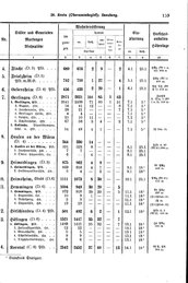
| Nr. | Stadtkreis Markungen Stadtteile |
Wohnbevölkerung | Einpfarrung | Verkehrs-anstalten Höhenlage | ||||||
|---|---|---|---|---|---|---|---|---|---|---|
| im ganzen | davon | |||||||||
| ev. | kath. | andere | Glau- bens- juden |
Son- stige | ||||||
| Christen | ev. | kath. | ||||||||
| 1 | 2 | 3 | 4 | 5 | 6 | 7 | 8 | 9 | 10 | |
| 4. | Flacht (D.5) Pfd. | 689 | 676 | 2 | 9 | - | 2 | 4.1 | 25.1 | PAg (Bf 1 u. 22) 409m |
| 5. | Friolzheim (D.5) Pfd. m. M.G. | 742 | 710 | 1 | 27 | - | 4 | 5.1 | 25.1 | PAg (Bf 1) 450m |
| 6. | Gebersheim (D.4) Pfd. | 456 | 433 | 2 | 20 | - | 1 | 6.1 | 25.1 | PH TH (Bf P 1) 412m |
| 7. | Gerlingen (D.8) | 2671 | 2621 | 101 | 85 | 1 | 63 | |||
| 1. Gerlingen, Pfd. | 2671 | 2438 | 71 | 80 | 1 | 51 | 7.1 | 5[1] | ZwPA ü. Stu. 5 (Bf 1 u. 2) 336m | |
| 2. Bopser, Hsr. | 56 | 41 | 12 | - | - | 3 | 7.1 | 5[1] | ||
| 3. Forchenrain, Hsr. | 28 | 21 | - | - | - | 7 | 7.1 | 5[1] | ||
| 4. Gerlinger Heide, Hsr. | 4 | 4 | - | - | - | - | 7.1 | 5[1] | ||
| 5. Laichle, Hsr. | 21 | 10 | 11 | - | - | - | 7.1 | 5[1] | ||
| 6. Schillerhöhe, Hsr. | 67 | 58 | 3 | 4 | - | 2 | 7.1 | 5[1] | ||
| 2. Solitude, Staatsdomäne, Schl. u. Hsr. | 54 | 49 | 4 | 1 | - | - | 7.1 | 5[1] | (P Stu.3) | |
| 8. | Hausen an der Würm (D.4) | 344 | 330 | 14 | - | - | - | |||
| 1. Hausen an der Würm, Pfd. | 331 | 323 | 8 | - | - | - | 8.1 | 25.1 | PSt ü. 25 (Bf 21) 384m | |
| 2. Frohnmühle, Hs. | 7 | 7 | - | - | - | - | 8.1 | 25.1 | ||
| 3. Obere Sägmühle, Hs. | 6 | - | 6 | - | - | - | 8.1 | 25.1 | ||
| 9. | Heimerdingen (D.5) | 875 | 862 | 4 | 9 | - | - | |||
| 1. Heimerdingen, Pfd. | 869 | 858 | 4 | 7 | - | - | 9.1 | 18[1] | Bf PAg 408m | |
| 2. Haldenwaldmühle, Hs. | 6 | 4 | 4 | - | 2 | - | 9.1 | 18[1] | ||
| 10. | Heimsheim Stadt (D.6) | 1111 | 1073 | 8 | 30 | - | - | 10.1 | 25.1 | PAg (Bf 25) 413m |
| 11. | Hemmingen (D.6) | 1004 | 949 | 30 | 20 | - | 5 | |||
| 1. Hemmingen, Pfd. | 972 | 918 | 29 | 20 | - | 5 | 11.1 | 18[1] | Bf PAg 327m | |
| 2. Hagmühle, Hs. | 10 | 9 | 1 | - | - | - | 11.1 | 18[1] | (T 11 P Lud.15) | |
| 3. Rohrsperg, Hs. | 3 | 3 | - | - | - | - | 11.1 | 18[1] | (P 9) | |
| 4. Sägmühle, Hs. | 19 | 19 | - | - | - | - | 11.1 | 18[1] | (T 11 P Lud. 15) | |
| 12. | Hirschlanden (D.4) Pfd. | 501 | 492 | 6 | 2 | - | 1 | 12.1 | 18[1] | PSt ü. 2 (Bf 2) 335m |
| 13. | Höfingen (D.6) | 1521 | 1447 | 35 | 32 | - | 7 | |||
| 1. Höfingen, Pfd. | 1489 | 1415 | 35 | 32 | - | 7 | 13.1 | 18[1] | Hp PAg 381m | |
| 2. Felsensägmühle, Hs. | 12 | 12 | - | - | - | - | 13.1 | 18[1] | ||
| 3. Glaunhalde, Hs. | 5 | 5 | - | - | - | - | 13.1 | 18[1] | ||
| 4. Scheffelmühle, Hs. | 9 | 9 | - | - | - | - | 13.1 | 18[1] | ||
| 5. Tilghäuslesmühle, Hs. | 6 | 6 | - | - | - | - | 13.1 | 18[1] | ||
| 14. | Korntal (C.8) Pfd. | 2542 | 2452 | 37 | 40 | - | 13 | 14.1 | 18[1] | Bf T, PA 304m |