Württemberg/Staatshandbuch 1936/176: Unterschied zwischen den Versionen
Zur Navigation springen
Zur Suche springen
Keine Bearbeitungszusammenfassung |
Keine Bearbeitungszusammenfassung |
||
| (2 dazwischenliegende Versionen desselben Benutzers werden nicht angezeigt) | |||
| Zeile 1: | Zeile 1: | ||
<noinclude>{{Württemberg/Staatshandbuch 1936|175|184|177| | <noinclude>{{Württemberg/Staatshandbuch 1936|175|184|177|unkorrigiert}}</noinclude> | ||
{| class="wikitable" | {| class="wikitable" | ||
| Zeile 23: | Zeile 23: | ||
| style="width:15%"|10 | | style="width:15%"|10 | ||
|- | |- | ||
| '''(10.)''' || 3. Bruckmühle, Hsr. || | | '''(10.)''' || 3. Bruckmühle, Hsr. || 11 || 11 || - || - || - || - || 10.1 || 2.1<ref name= Mark10.1>Kreis Besigheim.</ref> || | ||
|- | |- | ||
| || 4. Landesfürsorgeanstalt, Hsr. || | | || 4. Landesfürsorgeanstalt, Hsr. || 357 || 302 || 53 || - || - || 2 || 10.1 || 2.1<ref name= Mark10.1/> || (P 1) | ||
|- | |- | ||
| || 5. Obere Mühle, Hs. || | | || 5. Obere Mühle, Hs. || 7 || 7 || - || - || - || - || 10.1 || 2.1<ref name= Mark10.1/> || | ||
|- | |- | ||
| || 6. Ölmühle, Hs. || | | || 6. Ölmühle, Hs. || 6 || - || - || 5 || - || 1 || 10.1 || 2.1<ref name= Mark10.1/> || | ||
|- | |- | ||
| || 7. Papiermühle, Hs. || | | || 7. Papiermühle, Hs. || 5 || 5 || - || - || - || - || 10.1 || 2.1<ref name= Mark10.1/> || | ||
|- | |- | ||
| || 8. Raisershaus, H. || | | || 8. Raisershaus, H. || 9 || 9 || - || - || - || - || 10.1 || 2.1<ref name= Mark10.1/> || | ||
|- | |- | ||
| || 9. Schönbühlhof, W. || | | || 9. Schönbühlhof, W. || 74 || 74 || - || - || - || - || 10.1 || 2.1<ref name= Mark10.1/> || GÖ | ||
|- | |- | ||
| || 10. Spitalmühle, Hs. || | | || 10. Spitalmühle, Hs. || 9 || 9 || - || - || - || - || 10.1 || 2.1<ref name= Mark10.1/> || | ||
|- | |- | ||
| || 11. Talhausen, W. || | | || 11. Talhausen, W. || 55 || 54 || 1 || - || - || - || 10.1 || 2.1<ref name= Mark10.1/> || | ||
|- | |- | ||
| || 12. Untere Mühle, Hs. || | | || 12. Untere Mühle, Hs. || 10 || 10 || - || - || - || - || 10.1 || 2.1<ref name= Mark10.1/> || | ||
|- | |- | ||
| || 13. Unteres Schafhaus, Hs. || | | || 13. Unteres Schafhaus, Hs. || 8 || 8 || - || - || - || - || 10.1 || 2.1<ref name= Mark10.1/> || | ||
|- | |- | ||
| | | | ||
|- | |- | ||
| '''11.''' || '''Möglingen''' (D.6) Pfd. || | | '''11.''' || '''Möglingen''' (D.6) Pfd. || 1367 || 1326 || 24 || 15 || - || 2 || 11.1 || 1.1 || Bf PAg <tt>297m</tt> | ||
|- | |- | ||
| | | | ||
|- | |- | ||
| '''12.''' || '''Neckargröningen''' (D.4) || | | '''12.''' || '''Neckargröningen''' (D.4) || 591 || 559 || 21 || 7 || - || 4 || || || | ||
|- | |- | ||
| || '''1. Neckargröningen,''' Pfd. || | | || '''1. Neckargröningen,''' Pfd. || 589 || 558 || 20 || 7 || - || 4 || 12.1 || 1.1 || PSt ü. Wbl. 1(Bf 1) <tt>211m</tt> | ||
|- | |- | ||
| || 2. Oberwiesen<ref> </ref>, Hsr. || | | || 2. Oberwiesen<ref>Der im Gebiet der Stadt Ludwigsburg liegende Teil der Häusergruppe Oberwiesen ist aud Seite 174 aufgezählt (1.3.1.b). </ref>, Hsr. || 2 || 1 || 1 || - || - || - || 12.1 || 1.1 || (T 1.3 P Wbl. 16) | ||
|- | |- | ||
| | | | ||
|- | |- | ||
| '''13.''' || '''Neckarweihingen''' (D.6) || | | '''13.''' || '''Neckarweihingen''' (D.6) || 1762 || 1679 || 47 || 15 || - || 21 || || || | ||
|- | |- | ||
| || '''1. Neckarweihingen,''' Pfd. || 2406 || 2144 || | | || '''1. Neckarweihingen,''' Pfd. || 2406 || 2144 || 47 || 15 || - || 21 || 13.1 || 1.1 || PAg ü. 1 (Bf 1) <tt>206m</tt> | ||
|- | |- | ||
| || 2. Hummelwiesen, Hs. || | | || 2. Hummelwiesen, Hs. || 7 || 7 || - || - || - || - || 1.1<ref name= Neck13.1>Kreis Marbach.</ref> || 1.1 || | ||
|- | |- | ||
| || 3. Makenhof, H. || | | || 3. Makenhof, H. || 11 || 10 || 1 || - || - || - || 1.1<ref name= Neck13.1/> || 1.1 || (P Mrb. 1) | ||
|- | |- | ||
| | | | ||
|- | |- | ||
| '''14.''' || '''Poppenweiler''' (D.6) Pfd. || | | '''14.''' || '''Poppenweiler''' (D.6) Pfd. || 1242 || 1209 || 10 || 17 || - || 6 || 14.1 || 1.1 || PAg ü. 1 (Bf 1) <tt>258m</tt> | ||
|- | |- | ||
| | | | ||
|- | |- | ||
| '''15.''' || '''Schwieberdingen''' (D.6) || | | '''15.''' || '''Schwieberdingen''' (D.6) || 1478 || 1395 || 13 || 61 || 1 || 8 || || || | ||
|- | |- | ||
| || '''1. Schwieberdingen,''' Pfd. || | | || '''1. Schwieberdingen,''' Pfd. || 1334 || 1254 || 10 || 61 || 1 || 8 || 15.1 || 1.1 || Bf PAg <tt>274m</tt> | ||
|- | |- | ||
| || 2. Hardthof, W. || | | || 2. Hardthof, W. || 106 || 106 || - || - || - || - || 15.1 || 1.1 || (T 10.9 P 10) | ||
|- | |- | ||
| || 3. Neumühle, Hs. || | | || 3. Neumühle, Hs. || 6 || 6 || - || - || - || - || 15.1 || 1.1 || | ||
|- | |- | ||
| || 4. Nippenburg, H. || | | || 4. Nippenburg, H. || 23 || 21 || 2 || - || - || - || 15.1 || 1.1 || | ||
|- | |- | ||
| || 5. Stumpenmühle, Hs. || | | || 5. Stumpenmühle, Hs. || 9 || 8 || 1 || - || - || - || 15.1 || 1.1 || | ||
|- | |- | ||
| | | | ||
|- | |- | ||
| '''16.''' || '''Stammheim''' (C.8) || | | '''16.''' || '''Stammheim''' (C.8) || 3670 || 2962 || 344 || 147 || - || 217 || || || | ||
|- | |- | ||
| || '''1. Stammheim,''' Pfd. || | | || '''1. Stammheim,''' Pfd. || 3654 || 2957 || 337 || 143 || - || 217 || 16.1 || 18<ref name= Stam16.1>Stadtkreis Stuttgart.</ref> || ZwPA (Bf 9) <tt>297m</tt> | ||
|- | |- | ||
| || 2. Neuwirtshaus, herzogliche Domäne, H. || | | || 2. Neuwirtshaus, herzogliche Domäne, H. || 16 || 5 || 7 || 4 || - || - || 16.1 || 18<ref name= Stam16.1/> || | ||
|- | |- | ||
| nbsp; | | | ||
|- | |- | ||
| '''17.''' || '''Tamm''' (C.6) || | | '''17.''' || '''Tamm''' (C.6) || 1731 || 1676 || 42 || 13 || - || - || || || | ||
|- | |- | ||
| || '''1. Tamm,''' Pfd. || | | || '''1. Tamm,''' Pfd. || 1646 || 1592 || 42 || 12 || - || - || 17.1 || 2.1<ref name= Mark10.1/> || Bf T PAg <tt>259m</tt> | ||
|- | |- | ||
| || 2. Fißlerhhof, W. || | | || 2. Fißlerhhof, W. || 48 || 47 || - || 1 || - || - || 17.1 || 2.1<ref name= Mark10.1/> || GÖ (P Bes. 2) | ||
|- | |- | ||
| || 3. Hohenstange, W. || | | || 3. Hohenstange, W. || 37 || 37 || - || - || - || - || 17.1 || 2.1<ref name= Mark10.1/> || | ||
|} | |} | ||
<references/> | <references/> | ||
Aktuelle Version vom 28. April 2014, 22:02 Uhr
| GenWiki - Digitale Bibliothek | |
|---|---|
| Württemberg/Staatshandbuch 1936 | |
| <<<Vorherige Seite [175] |
Nächste Seite>>> [177] |
| |
| Hilfe zur Nutzung von DjVu-Dateien | |
| Texterfassung: unkorrigiert | |
| Dieser Text wurde noch nicht korrekturgelesen und kann somit Fehler enthalten.
| |
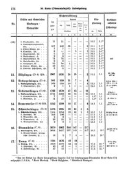
| Nr. | Stadtkreis Markungen Stadtteile |
Wohnbevölkerung | Einpfarrung | Verkehrs-anstalten Höhenlage | ||||||
|---|---|---|---|---|---|---|---|---|---|---|
| im ganzen | davon | |||||||||
| ev. | kath. | andere | Glau- bens- juden |
Son- stige | ||||||
| Christen | ev. | kath. | ||||||||
| 1 | 2 | 3 | 4 | 5 | 6 | 7 | 8 | 9 | 10 | |
| (10.) | 3. Bruckmühle, Hsr. | 11 | 11 | - | - | - | - | 10.1 | 2.1[1] | |
| 4. Landesfürsorgeanstalt, Hsr. | 357 | 302 | 53 | - | - | 2 | 10.1 | 2.1[1] | (P 1) | |
| 5. Obere Mühle, Hs. | 7 | 7 | - | - | - | - | 10.1 | 2.1[1] | ||
| 6. Ölmühle, Hs. | 6 | - | - | 5 | - | 1 | 10.1 | 2.1[1] | ||
| 7. Papiermühle, Hs. | 5 | 5 | - | - | - | - | 10.1 | 2.1[1] | ||
| 8. Raisershaus, H. | 9 | 9 | - | - | - | - | 10.1 | 2.1[1] | ||
| 9. Schönbühlhof, W. | 74 | 74 | - | - | - | - | 10.1 | 2.1[1] | GÖ | |
| 10. Spitalmühle, Hs. | 9 | 9 | - | - | - | - | 10.1 | 2.1[1] | ||
| 11. Talhausen, W. | 55 | 54 | 1 | - | - | - | 10.1 | 2.1[1] | ||
| 12. Untere Mühle, Hs. | 10 | 10 | - | - | - | - | 10.1 | 2.1[1] | ||
| 13. Unteres Schafhaus, Hs. | 8 | 8 | - | - | - | - | 10.1 | 2.1[1] | ||
| 11. | Möglingen (D.6) Pfd. | 1367 | 1326 | 24 | 15 | - | 2 | 11.1 | 1.1 | Bf PAg 297m |
| 12. | Neckargröningen (D.4) | 591 | 559 | 21 | 7 | - | 4 | |||
| 1. Neckargröningen, Pfd. | 589 | 558 | 20 | 7 | - | 4 | 12.1 | 1.1 | PSt ü. Wbl. 1(Bf 1) 211m | |
| 2. Oberwiesen[2], Hsr. | 2 | 1 | 1 | - | - | - | 12.1 | 1.1 | (T 1.3 P Wbl. 16) | |
| 13. | Neckarweihingen (D.6) | 1762 | 1679 | 47 | 15 | - | 21 | |||
| 1. Neckarweihingen, Pfd. | 2406 | 2144 | 47 | 15 | - | 21 | 13.1 | 1.1 | PAg ü. 1 (Bf 1) 206m | |
| 2. Hummelwiesen, Hs. | 7 | 7 | - | - | - | - | 1.1[3] | 1.1 | ||
| 3. Makenhof, H. | 11 | 10 | 1 | - | - | - | 1.1[3] | 1.1 | (P Mrb. 1) | |
| 14. | Poppenweiler (D.6) Pfd. | 1242 | 1209 | 10 | 17 | - | 6 | 14.1 | 1.1 | PAg ü. 1 (Bf 1) 258m |
| 15. | Schwieberdingen (D.6) | 1478 | 1395 | 13 | 61 | 1 | 8 | |||
| 1. Schwieberdingen, Pfd. | 1334 | 1254 | 10 | 61 | 1 | 8 | 15.1 | 1.1 | Bf PAg 274m | |
| 2. Hardthof, W. | 106 | 106 | - | - | - | - | 15.1 | 1.1 | (T 10.9 P 10) | |
| 3. Neumühle, Hs. | 6 | 6 | - | - | - | - | 15.1 | 1.1 | ||
| 4. Nippenburg, H. | 23 | 21 | 2 | - | - | - | 15.1 | 1.1 | ||
| 5. Stumpenmühle, Hs. | 9 | 8 | 1 | - | - | - | 15.1 | 1.1 | ||
| 16. | Stammheim (C.8) | 3670 | 2962 | 344 | 147 | - | 217 | |||
| 1. Stammheim, Pfd. | 3654 | 2957 | 337 | 143 | - | 217 | 16.1 | 18[4] | ZwPA (Bf 9) 297m | |
| 2. Neuwirtshaus, herzogliche Domäne, H. | 16 | 5 | 7 | 4 | - | - | 16.1 | 18[4] | ||
| 17. | Tamm (C.6) | 1731 | 1676 | 42 | 13 | - | - | |||
| 1. Tamm, Pfd. | 1646 | 1592 | 42 | 12 | - | - | 17.1 | 2.1[1] | Bf T PAg 259m | |
| 2. Fißlerhhof, W. | 48 | 47 | - | 1 | - | - | 17.1 | 2.1[1] | GÖ (P Bes. 2) | |
| 3. Hohenstange, W. | 37 | 37 | - | - | - | - | 17.1 | 2.1[1] | ||