Württemberg/Staatshandbuch 1936/197: Unterschied zwischen den Versionen
Zur Navigation springen
Zur Suche springen
Keine Bearbeitungszusammenfassung |
Keine Bearbeitungszusammenfassung |
||
| (5 dazwischenliegende Versionen desselben Benutzers werden nicht angezeigt) | |||
| Zeile 1: | Zeile 1: | ||
<noinclude>{{Württemberg/Staatshandbuch 1936|196|205|198| | <noinclude>{{Württemberg/Staatshandbuch 1936|196|205|198|unkorrigiert}}</noinclude> | ||
{| class="wikitable" | {| class="wikitable" | ||
| Zeile 23: | Zeile 23: | ||
| style="width:15%"|10 | | style="width:15%"|10 | ||
|- | |- | ||
| ''' | | '''17.''' || '''Gültlingen''' (D.4) || 887 || 871 || 9 || 6 || - || 1 || || || | ||
|- | |- | ||
| || '''1. | | || '''1. Gültlingen,''' Pfd. || 851 || 838 || 6 || 6 || - || 1 || 17.1 || 1.1 || PAg ü. Cal. 1 (Bf 37) <tt>455m</tt> | ||
|- | |- | ||
| || 2. | | || 2. Haselstall, W. || 16 || 16 || - || - || - || - || 17.1 || 1.1 || (P Cal. 12) | ||
|- | |||
| || 3. Obere Papiermühle, Hsr. || 4 || 1 || 3 || - || - || - || 17.1 || 1.1 || (P 37) | |||
|- | |||
| || 4. Untere Papiermühle, Hsr. || 3 || 3 || - || - || - || - || 17.1 || 1.1 || (P 37) | |||
|- | |||
| || 5. Untere Sägmühle, Hsr. || 7 || 7 || - || - || - || - || 17.1 || 1.1 || | |||
|- | |||
| || 6. Ziegelhütte, Hs. || 6 || 6 || - || - || - || - || 17.1 || 1.1 || | |||
|- | |||
| | |||
|- | |||
| '''18.''' || '''Haiterbach,''' Stadt (D.6) || 1694 || 1643 || 37 || 8 || - || 6 || || || | |||
|- | |||
| || '''1. Haiterbach,''' Stadt || 1636 || 1585 || 37 || 8 || - || 6 || 18.1 || 14.1<ref name= Hait18.1>Kreis Horb.</ref> || PAg (Bf Horb 14) <tt>506m</tt> | |||
|- | |||
| || '''2. Altnuifra,''' W. || 58 || 58 || - || - || - || - || 18.1 || 24.1<ref name= Hait18.1/> || TH | |||
|- | |- | ||
| | | | ||
|- | |- | ||
| ''' | | '''19.''' || '''Iselshausen''' (D.4) D. || 462 || 431 || 13 || 17 || - || 1 || 1.1 || 14.1<ref name= Hait18.1/> || Hp PSt ü. 1 <tt>414m</tt> | ||
|- | |- | ||
| | | | ||
|- | |- | ||
| || | | '''20.''' || '''Mindersbach''' (D.4) D. || 317 || 316 || 1 || - || - || - || 24.1 || 1.1 || PSt ü. 1 (Bf 24) <tt>536m</tt> | ||
|- | |- | ||
| | | | ||
|- | |- | ||
| | | '''21.''' || '''Oberschwandorf''' (D.4) D. || 458 || 466 || 3 || 9 || - || - || 34.1 || 1.1 || PSt ü. 1 (Bf 1) <tt>457m</tt> | ||
|- | |||
| | |||
|- | |||
| '''22.''' || '''Obertalheim''' (D.4) || 607 || 9 || 598 || - || - || - || || || | |||
|- | |||
| || '''1. Obertalheim,''' D. || 594 || 9 || 585 || - || - || - || 18.1 || 33.1 || PSt ü. Horb 1 (Bf Horb 14) <tt>515m</tt> | |||
|- | |||
| || 2. Ziegelhof, Hs. || 13 || - || 13 || - || - || - || 18.1 || 33.1 || | |||
|- | |||
| | |||
|- | |||
| '''23.''' || '''Pfrondorf''' (D.4) || 272 || 266 || - || 6 || - || - || || || | |||
|- | |||
| || '''1. Pfrondorf,''' D. || 265 || 259 || - || 6 || - || - || 12.1 || 1.1 || PSt ü. 1 (Bf 12) <tt>450m</tt> | |||
|- | |||
| || 2. Pfrondorfer Mühle, Hs. || 7 || 7 || - || - || - || - || 12.1 || 1.1 || | |||
|- | |||
| | |||
|- | |||
| '''24.''' || '''Rohrdorf''' (D.5) || 712 || 676 || 33 || 3 || - || - || || || | |||
|- | |||
| || '''1. Rohrdorf,''' Pfd. || 712 || 676 || 33 || 3 || - || - || 24.1 || 1.1 || Bf PAg <tt>418m</tt> | |||
|- | |||
| || 2. Kämmerle<ref>Ohne Wohnbevölkerung bei der Volkszählung am 16. Juni 1933.</ref>, Hsr. || - || - || - || - || - || - || - || - || | |||
|- | |||
| | |||
|- | |||
| '''25.''' || '''Rotfelden''' (D.4) || 635 || 613 || - || 22 || - || 1 || || || | |||
|- | |||
| || '''1. Rotfelden,''' Pfd. || 618 || 596 || - || 22 || - || - || 25.1 || 1.1 || PSt ü. 1 (Bf 9) <tt>493m</tt> | |||
|- | |||
| || 2. Ziegelhütte, Hsr. || 17 || 17 || - || - || - || - || 25.1 || 1.1 || | |||
|- | |||
| | |||
|- | |||
| '''26.''' || '''Schietingen''' (D.4) D. || 302 || 271 || 11 || 15 || - || 5 || 15.1<ref name= Hait18.1/> || 14.1<ref name= Hait18.1/> || PSt ü. Horb 1 (Bf Horb 14) <tt>460m</tt> | |||
|- | |||
| | |||
|- | |||
| '''27.''' || '''Schönbronn''' (D.4) D. || 464 || 463 || - || 1 || - || - || 10.1 || 1.1 || PSt ü. 1 (Bf 37) <tt>561m</tt> | |||
|} | |} | ||
<references/> | |||
Aktuelle Version vom 16. November 2013, 20:16 Uhr
| GenWiki - Digitale Bibliothek | |
|---|---|
| Württemberg/Staatshandbuch 1936 | |
| <<<Vorherige Seite [196] |
Nächste Seite>>> [198] |
| |
| Hilfe zur Nutzung von DjVu-Dateien | |
| Texterfassung: unkorrigiert | |
| Dieser Text wurde noch nicht korrekturgelesen und kann somit Fehler enthalten.
| |
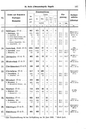
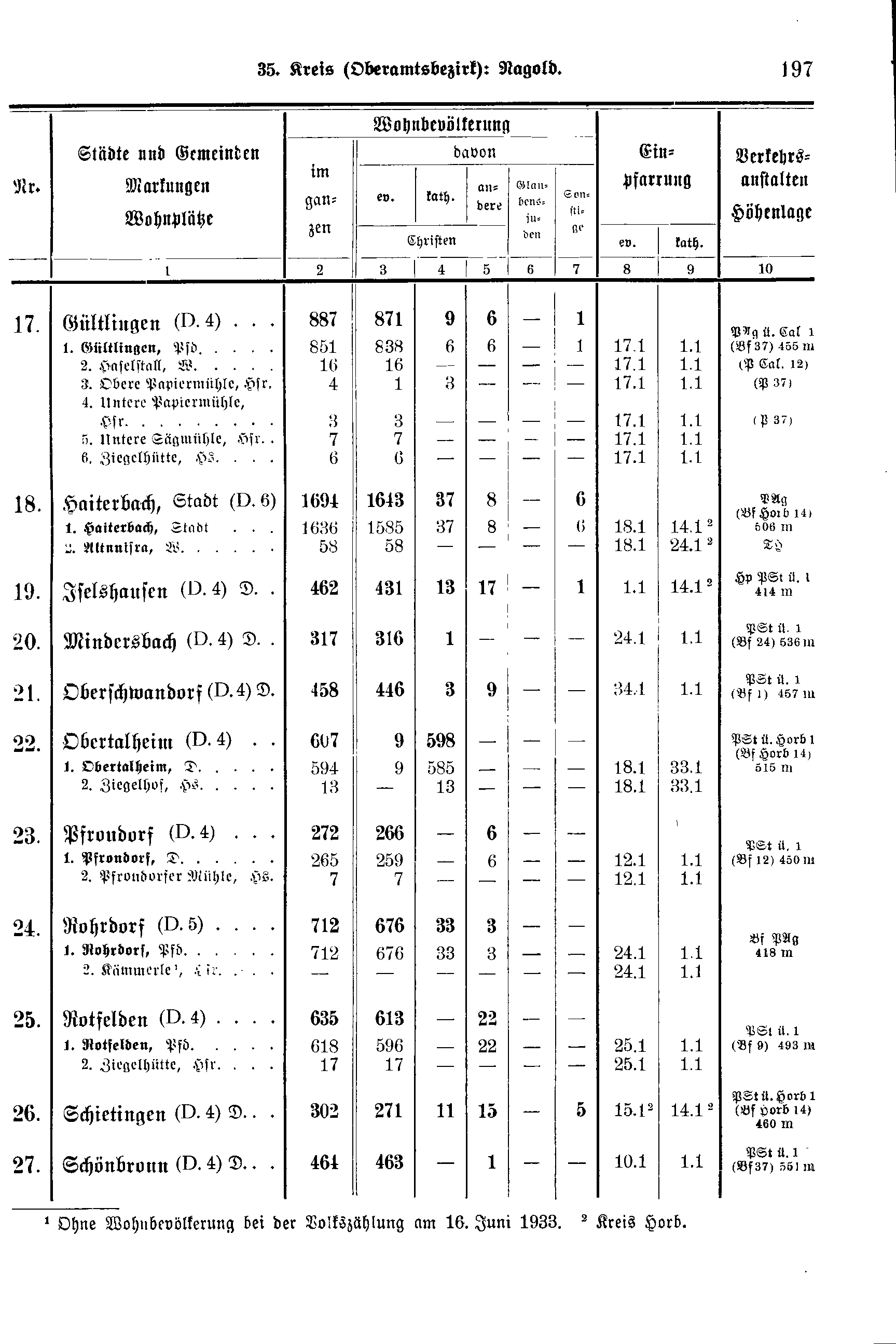
| Nr. | Stadtkreis Markungen Stadtteile |
Wohnbevölkerung | Einpfarrung | Verkehrs-anstalten Höhenlage | ||||||
|---|---|---|---|---|---|---|---|---|---|---|
| im ganzen | davon | |||||||||
| ev. | kath. | andere | Glau- bens- juden |
Son- stige | ||||||
| Christen | ev. | kath. | ||||||||
| 1 | 2 | 3 | 4 | 5 | 6 | 7 | 8 | 9 | 10 | |
| 17. | Gültlingen (D.4) | 887 | 871 | 9 | 6 | - | 1 | |||
| 1. Gültlingen, Pfd. | 851 | 838 | 6 | 6 | - | 1 | 17.1 | 1.1 | PAg ü. Cal. 1 (Bf 37) 455m | |
| 2. Haselstall, W. | 16 | 16 | - | - | - | - | 17.1 | 1.1 | (P Cal. 12) | |
| 3. Obere Papiermühle, Hsr. | 4 | 1 | 3 | - | - | - | 17.1 | 1.1 | (P 37) | |
| 4. Untere Papiermühle, Hsr. | 3 | 3 | - | - | - | - | 17.1 | 1.1 | (P 37) | |
| 5. Untere Sägmühle, Hsr. | 7 | 7 | - | - | - | - | 17.1 | 1.1 | ||
| 6. Ziegelhütte, Hs. | 6 | 6 | - | - | - | - | 17.1 | 1.1 | ||
| 18. | Haiterbach, Stadt (D.6) | 1694 | 1643 | 37 | 8 | - | 6 | |||
| 1. Haiterbach, Stadt | 1636 | 1585 | 37 | 8 | - | 6 | 18.1 | 14.1[1] | PAg (Bf Horb 14) 506m | |
| 2. Altnuifra, W. | 58 | 58 | - | - | - | - | 18.1 | 24.1[1] | TH | |
| 19. | Iselshausen (D.4) D. | 462 | 431 | 13 | 17 | - | 1 | 1.1 | 14.1[1] | Hp PSt ü. 1 414m |
| 20. | Mindersbach (D.4) D. | 317 | 316 | 1 | - | - | - | 24.1 | 1.1 | PSt ü. 1 (Bf 24) 536m |
| 21. | Oberschwandorf (D.4) D. | 458 | 466 | 3 | 9 | - | - | 34.1 | 1.1 | PSt ü. 1 (Bf 1) 457m |
| 22. | Obertalheim (D.4) | 607 | 9 | 598 | - | - | - | |||
| 1. Obertalheim, D. | 594 | 9 | 585 | - | - | - | 18.1 | 33.1 | PSt ü. Horb 1 (Bf Horb 14) 515m | |
| 2. Ziegelhof, Hs. | 13 | - | 13 | - | - | - | 18.1 | 33.1 | ||
| 23. | Pfrondorf (D.4) | 272 | 266 | - | 6 | - | - | |||
| 1. Pfrondorf, D. | 265 | 259 | - | 6 | - | - | 12.1 | 1.1 | PSt ü. 1 (Bf 12) 450m | |
| 2. Pfrondorfer Mühle, Hs. | 7 | 7 | - | - | - | - | 12.1 | 1.1 | ||
| 24. | Rohrdorf (D.5) | 712 | 676 | 33 | 3 | - | - | |||
| 1. Rohrdorf, Pfd. | 712 | 676 | 33 | 3 | - | - | 24.1 | 1.1 | Bf PAg 418m | |
| 2. Kämmerle[2], Hsr. | - | - | - | - | - | - | - | - | ||
| 25. | Rotfelden (D.4) | 635 | 613 | - | 22 | - | 1 | |||
| 1. Rotfelden, Pfd. | 618 | 596 | - | 22 | - | - | 25.1 | 1.1 | PSt ü. 1 (Bf 9) 493m | |
| 2. Ziegelhütte, Hsr. | 17 | 17 | - | - | - | - | 25.1 | 1.1 | ||
| 26. | Schietingen (D.4) D. | 302 | 271 | 11 | 15 | - | 5 | 15.1[1] | 14.1[1] | PSt ü. Horb 1 (Bf Horb 14) 460m |
| 27. | Schönbronn (D.4) D. | 464 | 463 | - | 1 | - | - | 10.1 | 1.1 | PSt ü. 1 (Bf 37) 561m |