Württemberg/Staatshandbuch 1936/064: Unterschied zwischen den Versionen
Zur Navigation springen
Zur Suche springen
(automatisch angelegt) |
Keine Bearbeitungszusammenfassung |
||
| (4 dazwischenliegende Versionen desselben Benutzers werden nicht angezeigt) | |||
| Zeile 1: | Zeile 1: | ||
<noinclude>{{Württemberg/Staatshandbuch 1936|063|72|065| | <noinclude>{{Württemberg/Staatshandbuch 1936|063|72|065|unkorrigiert}}</noinclude> | ||
{| class="wikitable" | |||
|- | |||
! rowspan="4"| Nr.||rowspan="4"| Stadtkreis<br/> Markungen<br/> Stadtteile !! colspan="6"| Wohnbevölkerung !! colspan="2" rowspan="3" |Einpfarrung !! rowspan="4"| Verkehrs-anstalten<br/> Höhenlage | |||
|- | |||
! rowspan="3"| im ganzen || colspan="5"| davon | |||
|- | |||
! ev. || kath. || andere|| rowspan="2" | Glau-<br/>bens-<br/>juden|| rowspan="2" | Son-<br/>stige | |||
|- | |||
! colspan="3" | Christen || ev. || kath. | |||
|- style="text-align:center" | |||
| style="width:3%"| | |||
| style="width:25%"|1 | |||
| style="width:5%"|2 | |||
| style="width:5%"|3 | |||
| style="width:5%"|4 | |||
| style="width:5%"|5 | |||
| style="width:5%"|6 | |||
| style="width:5%"|7 | |||
| style="width:5%"|8 | |||
| style="width:5%"|9 | |||
| style="width:15%"|10 | |||
|- | |||
| (8.) || '''15. Ropfershof,''' W. || 23 || - || 23 || - || - || - || 16.1<ref name= Elle6.1>Kreis Crailsheim.</ref> || 19.1<ref name= Elle6.1/> || (T Crls. 16) | |||
|- | |||
| || '''16. Rot,''' W. || 42 || 5 || 37 || - || - || - || 16.1<ref name= Elle6.1/> || 19.1<ref name= Elle6.1/> || (T Crls. 16) | |||
|- | |||
| || '''17. Rothof,''' W. || 13 || 5 || 8 || - || - || - || 16.1<ref name= Elle6.1/> || 19.1<ref name= Elle6.1/> || (T Crls. 16) | |||
|- | |||
| || '''18. Schweighausen,''' W. || 48 || - || 48 || - || - || - || 16.1<ref name= Elle6.1/> || 8.1 || Hp | |||
|- | |||
| || '''19. Spielegert,''' W. || 16 || - || 16 || - || - || - || 6.1<ref name= Elle6.1/> || 8.1 || | |||
|- | |||
| || '''20. Weiler,''' W. || 208 || - || 208 || - || - || - || 16.1<ref name= Elle6.1/> || 8.1 || | |||
|- | |||
| || 2. Kellerhof, H. || 14 || - || 14 || - || - || - || 16.1<ref name= Elle6.1/> || 8.1 || | |||
|- | |||
| || '''21. Winterberg,''' W. || 23 || - || 23 || - || - || - || 16.1<ref name= Elle6.1/> || 8.1 || | |||
|- | |||
| | |||
|- | |||
| '''9.''' || '''Lauchheim,''' Stadt (D.8) || 1066 || 48 || 1009 || 1 || 7 || 1 || || || | |||
|- | |||
| || '''1. Lauchheim,''' Stadt || 904 || 32 || 863 || 1 || 7 || 1 || 6.1<ref name= Lauc9.1>Kreis Neresheim.</ref>|| 9.1 || Bf T, PAg <tt>492 m</tt> | |||
|- | |||
| || 2. Banzenmühle, Hs. || 6 || - || 6 || - || - || - || 6.1<ref name= Lauc9.1/> || 9.1 || (P 24.7) | |||
|- | |||
| || 3. Fuchsmühle, Hs. || 4 || 4 || - || - || - || - || 6.1<ref name= Lauc9.1/> || 9.1 || | |||
|- | |||
| || 4. Haltepunkt Röttingen, Hs. || 7 || - || 7 || - || - || - || 6.1<ref name= Lauc9.1/> || 9.1 || Hp | |||
|- | |||
| || '''2. Beerhalden,''' H. || 5 || - || 5 || - || - || - || 6.1<ref name= Lauc9.1/> || 10.1 || (P 10) | |||
|- | |||
| || '''3. Forst und Vogel''' (m.Bez.): || || || || || || || || || | |||
|- | |||
| || 1. Forst, H. || 4 || 2 || 2 || - || - || - || 6.1<ref name= Lauc9.1/> || 10.1 || (P 10) | |||
|- | |||
| || 2. Vogel, H. || 10 || - || 10 || - || - || - || 6.1<ref name= Lauc9.1/> || 10.1 || (P 10) | |||
|- | |||
| || '''4. Gromberg,''' W. || 29 || 1 || 28 || - || - || - || 6.1<ref name= Lauc9.1/> || 9.1 || | |||
|- | |||
| || '''5. Hettelsberg,''' W. || 14 || - || 14 || - || - || - || 6.1<ref name= Lauc9.1/> || 9.1 || | |||
|- | |||
| || '''6. Lindstetten'''<ref name= unbew>Unbewohnte Markung.</ref> || - || - || - || - || - || - || - || - || | |||
|- | |||
| || '''7. Mohrenstetten,''' H. || 11 || - || 11 || - || - || - || 6.1<ref name= Lauc9.1/> || 9.1 || (P 24.7) | |||
|- | |||
| || '''8. Schömberg,''' H. || 19 || 9 || 10 || - || - || - || 6.1<ref name= Lauc9.1/> || 9.1 || (P 24.7) | |||
|- | |||
| || '''9. Stetten,''' W. || 53 || - || 53 || - || - || - || 6.1<ref name= Lauc9.1/> || 9.1 || (T 9 P 10) | |||
|- | |||
| | |||
|- | |||
| '''10.''' || '''Lippach''' (D.4) || 480 || 8 || 472 || - || - || - || || || | |||
|- | |||
| || '''1. Lippach,''' Pfd. || 404 || - || 404 || - || - || - || 6.1<ref name= Lauc9.1/> || 10.1 || PSt ü. Aal. 1 (Bf 9) <tt>498 m</tt> | |||
|- | |||
| || 2. Stockmühle, Hs. || 4 || 3 || 1 || - || - || - || 6.1<ref name= Lauc9.1/> || 10.1 || | |||
|- | |||
| || '''2. Berg,''' W. || 25 || - || 25 || - || - || - || 6.1<ref name= Lauc9.1/> || 10.1 || | |||
|- | |||
| || '''3. Finkenweiler,''' H. || 14 || - || 14 || - || - || - || 6.1<ref name= Lauc9.1/> || 10.1 || | |||
|- | |||
| || '''4. Hundslohe,''' H. || 7 || - || 7 || - || - || - || 6.1<ref name= Lauc9.1/> || 10.1 || | |||
|- | |||
| || '''5. Lindorf,''' W. || 26 || 5 || 21 || - || - || - || 23.1 || 10.1 || | |||
|- | |||
| | |||
|- | |||
| '''11.''' || '''Neuler''' (D.7) || 1514 || 84 || 1427 || 1 || - || 2 || || || | |||
|- | |||
| || '''1. Neuler,''' Pfd. || 698 || 14 || 682 || - || - || 2 || 3.1<ref name= Neul11.1>Kreis Aalen.</ref> || 11.1 || PAg ü. 1 (Bf 1) <tt>504 m</tt> | |||
|- | |||
| || 2. Adlersteige, Hs. || 7 || - || 7 || - || - || - || 3.1<ref name= Neul11.1/> || 11.1 || | |||
|- | |||
| || 3. Schlierhof, H. || 4 || - || 4 || - || - || - || 3.1<ref name= Neul11.1/> || 11.1 || | |||
|- | |||
| || 4. Schliermühle, Hs. || 3 || - || 3 || - || - || - || 3.1<ref name= Neul11.1/> || 11.1 || | |||
|- | |||
| || '''2. Bronnen,''' W. || 133 || - || 133 || - || - || - || 3.1<ref name= Neul11.1/> || 11.1 || TH | |||
|- | |||
| || 2. Binderhof, H. || 5 || - || 5 || - || - || - || 3.1<ref name= Neul11.1/> || 11.1 || (T 11.2) | |||
|- | |||
| || '''3. Burghardsmühle,''' Hs. || 6 || 1 || 5 || - || - || - || 3.1<ref name= Neul11.1/> || 11.1 || (P Aal. 3) | |||
|- | |||
| || '''4. Burgstall'''<ref name= unbew/> || - || - || - || - || - || - || - || - || | |||
|- | |||
| || '''5. Ebnat,''' W. || 76 || 2 || 74 || - || - || - || 3.1<ref name= Neul11.1/> || 11.1 || GÖ | |||
|- | |||
| || 2. Kohlwasen, Hsr. || 17 || - || 17 || - || - || - || 3.1<ref name= Neul11.1/> || 11.1 || (T 11.2) | |||
|} | |||
<references/> | |||
Aktuelle Version vom 29. September 2013, 09:57 Uhr
| GenWiki - Digitale Bibliothek | |
|---|---|
| Württemberg/Staatshandbuch 1936 | |
| <<<Vorherige Seite [063] |
Nächste Seite>>> [065] |

| |
| Hilfe zur Nutzung von DjVu-Dateien | |
| Texterfassung: unkorrigiert | |
| Dieser Text wurde noch nicht korrekturgelesen und kann somit Fehler enthalten.
| |
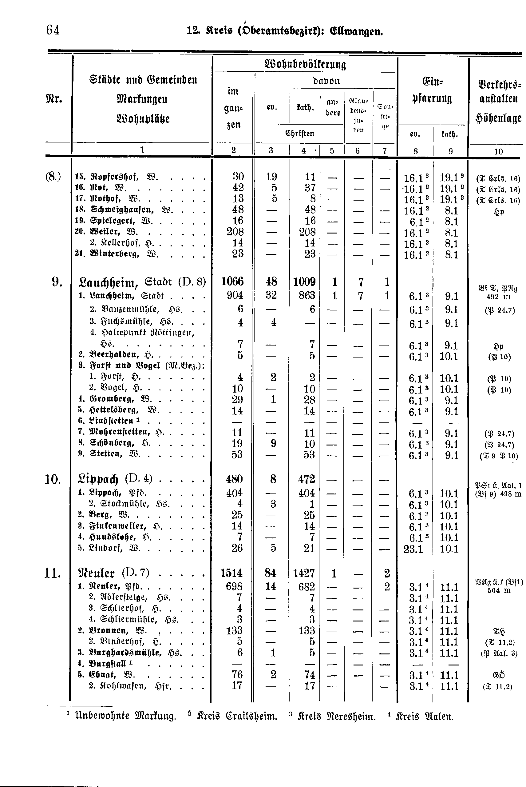
| Nr. | Stadtkreis Markungen Stadtteile |
Wohnbevölkerung | Einpfarrung | Verkehrs-anstalten Höhenlage | ||||||
|---|---|---|---|---|---|---|---|---|---|---|
| im ganzen | davon | |||||||||
| ev. | kath. | andere | Glau- bens- juden |
Son- stige | ||||||
| Christen | ev. | kath. | ||||||||
| 1 | 2 | 3 | 4 | 5 | 6 | 7 | 8 | 9 | 10 | |
| (8.) | 15. Ropfershof, W. | 23 | - | 23 | - | - | - | 16.1[1] | 19.1[1] | (T Crls. 16) |
| 16. Rot, W. | 42 | 5 | 37 | - | - | - | 16.1[1] | 19.1[1] | (T Crls. 16) | |
| 17. Rothof, W. | 13 | 5 | 8 | - | - | - | 16.1[1] | 19.1[1] | (T Crls. 16) | |
| 18. Schweighausen, W. | 48 | - | 48 | - | - | - | 16.1[1] | 8.1 | Hp | |
| 19. Spielegert, W. | 16 | - | 16 | - | - | - | 6.1[1] | 8.1 | ||
| 20. Weiler, W. | 208 | - | 208 | - | - | - | 16.1[1] | 8.1 | ||
| 2. Kellerhof, H. | 14 | - | 14 | - | - | - | 16.1[1] | 8.1 | ||
| 21. Winterberg, W. | 23 | - | 23 | - | - | - | 16.1[1] | 8.1 | ||
| 9. | Lauchheim, Stadt (D.8) | 1066 | 48 | 1009 | 1 | 7 | 1 | |||
| 1. Lauchheim, Stadt | 904 | 32 | 863 | 1 | 7 | 1 | 6.1[2] | 9.1 | Bf T, PAg 492 m | |
| 2. Banzenmühle, Hs. | 6 | - | 6 | - | - | - | 6.1[2] | 9.1 | (P 24.7) | |
| 3. Fuchsmühle, Hs. | 4 | 4 | - | - | - | - | 6.1[2] | 9.1 | ||
| 4. Haltepunkt Röttingen, Hs. | 7 | - | 7 | - | - | - | 6.1[2] | 9.1 | Hp | |
| 2. Beerhalden, H. | 5 | - | 5 | - | - | - | 6.1[2] | 10.1 | (P 10) | |
| 3. Forst und Vogel (m.Bez.): | ||||||||||
| 1. Forst, H. | 4 | 2 | 2 | - | - | - | 6.1[2] | 10.1 | (P 10) | |
| 2. Vogel, H. | 10 | - | 10 | - | - | - | 6.1[2] | 10.1 | (P 10) | |
| 4. Gromberg, W. | 29 | 1 | 28 | - | - | - | 6.1[2] | 9.1 | ||
| 5. Hettelsberg, W. | 14 | - | 14 | - | - | - | 6.1[2] | 9.1 | ||
| 6. Lindstetten[3] | - | - | - | - | - | - | - | - | ||
| 7. Mohrenstetten, H. | 11 | - | 11 | - | - | - | 6.1[2] | 9.1 | (P 24.7) | |
| 8. Schömberg, H. | 19 | 9 | 10 | - | - | - | 6.1[2] | 9.1 | (P 24.7) | |
| 9. Stetten, W. | 53 | - | 53 | - | - | - | 6.1[2] | 9.1 | (T 9 P 10) | |
| 10. | Lippach (D.4) | 480 | 8 | 472 | - | - | - | |||
| 1. Lippach, Pfd. | 404 | - | 404 | - | - | - | 6.1[2] | 10.1 | PSt ü. Aal. 1 (Bf 9) 498 m | |
| 2. Stockmühle, Hs. | 4 | 3 | 1 | - | - | - | 6.1[2] | 10.1 | ||
| 2. Berg, W. | 25 | - | 25 | - | - | - | 6.1[2] | 10.1 | ||
| 3. Finkenweiler, H. | 14 | - | 14 | - | - | - | 6.1[2] | 10.1 | ||
| 4. Hundslohe, H. | 7 | - | 7 | - | - | - | 6.1[2] | 10.1 | ||
| 5. Lindorf, W. | 26 | 5 | 21 | - | - | - | 23.1 | 10.1 | ||
| 11. | Neuler (D.7) | 1514 | 84 | 1427 | 1 | - | 2 | |||
| 1. Neuler, Pfd. | 698 | 14 | 682 | - | - | 2 | 3.1[4] | 11.1 | PAg ü. 1 (Bf 1) 504 m | |
| 2. Adlersteige, Hs. | 7 | - | 7 | - | - | - | 3.1[4] | 11.1 | ||
| 3. Schlierhof, H. | 4 | - | 4 | - | - | - | 3.1[4] | 11.1 | ||
| 4. Schliermühle, Hs. | 3 | - | 3 | - | - | - | 3.1[4] | 11.1 | ||
| 2. Bronnen, W. | 133 | - | 133 | - | - | - | 3.1[4] | 11.1 | TH | |
| 2. Binderhof, H. | 5 | - | 5 | - | - | - | 3.1[4] | 11.1 | (T 11.2) | |
| 3. Burghardsmühle, Hs. | 6 | 1 | 5 | - | - | - | 3.1[4] | 11.1 | (P Aal. 3) | |
| 4. Burgstall[3] | - | - | - | - | - | - | - | - | ||
| 5. Ebnat, W. | 76 | 2 | 74 | - | - | - | 3.1[4] | 11.1 | GÖ | |
| 2. Kohlwasen, Hsr. | 17 | - | 17 | - | - | - | 3.1[4] | 11.1 | (T 11.2) | |