Württemberg/Staatshandbuch 1936/082: Unterschied zwischen den Versionen
Zur Navigation springen
Zur Suche springen
(automatisch angelegt) |
Keine Bearbeitungszusammenfassung |
||
| (5 dazwischenliegende Versionen desselben Benutzers werden nicht angezeigt) | |||
| Zeile 1: | Zeile 1: | ||
<noinclude>{{Württemberg/Staatshandbuch 1936|081|90|083| | <noinclude>{{Württemberg/Staatshandbuch 1936|081|90|083|unkorrigiert}}</noinclude> | ||
{| class="wikitable" | |||
|- | |||
! rowspan="4"| Nr.||rowspan="4"| Stadtkreis<br/> Markungen<br/> Stadtteile !! colspan="6"| Wohnbevölkerung !! colspan="2" rowspan="3" |Einpfarrung !! rowspan="4"| Verkehrs-anstalten<br/> Höhenlage | |||
|- | |||
! rowspan="3"| im ganzen || colspan="5"| davon | |||
|- | |||
! ev. || kath. || andere|| rowspan="2" | Glau-<br/>bens-<br/>juden|| rowspan="2" | Son-<br/>stige | |||
|- | |||
! colspan="3" | Christen || ev. || kath. | |||
|- style="text-align:center" | |||
| style="width:3%"| | |||
| style="width:25%"|1 | |||
| style="width:5%"|2 | |||
| style="width:5%"|3 | |||
| style="width:5%"|4 | |||
| style="width:5%"|5 | |||
| style="width:5%"|6 | |||
| style="width:5%"|7 | |||
| style="width:5%"|8 | |||
| style="width:5%"|9 | |||
| style="width:15%"|10 | |||
|- | |||
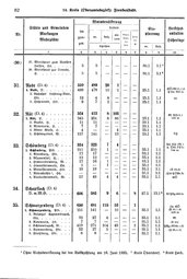
| (30.) || 27. Wirtshaus zum Rauhen Felsen, Hs. || 5 || 5 || - || - || - || - || 30.1 || 3.1<ref name= Rein30.1>Kreis Oberndorf.</ref> || | |||
|- | |||
| || 28. Wirtshaus zur Traube, H. || 5 || 5 || - || - || - || - || 30.1 || 3.1<ref name= Rein30.1/> || | |||
|- | |||
| | |||
|- | |||
| '''31.''' || '''Rodt''' (D.4) || 510 || 489 || 20 || 1 || - || - || || || | |||
|- | |||
| || '''1. Rodt,''' D. || 489 || 478 || 10 || 1 || - || - || 25.1 || 1.1 || GÖ (Bf 31.1.2 P 25) <tt>683m</tt> | |||
|- | |||
| || 2. Bahnhof Loßburg-Rodt, Hsr. || 12 || 4 || 8 || - || - || - || 25.1 || 1.1 || Bf | |||
|- | |||
| || 3. Hohenrodt, Hsr. || 9 || 7 || 2 || - || - || - || 25.1 || 1.1 || | |||
|- | |||
| | |||
|- | |||
| '''32.''' || '''Röt''' (D.4) || 524 || 413 || 8 || 103 || - || - || || || | |||
|- | |||
| || '''1. Röt,''' D. || 345 || 251 || 8 || 86 || - || - || 23.1 || 1.1 || Bf PSt ü. 1 <tt>500m</tt> | |||
|- | |||
| || 2. Buckel, H. || 11 || 11 || - || - || - || - || 23.1 || 1.1 || | |||
|- | |||
| || 3. Ritterrain, H. || 7 || 7 || - || - || - || - || 23.1 || 1.1 || | |||
|- | |||
| || 4. Röter Wiese, H. || 4 || - || - || 4 || - || - || 23.1 || 1.1 || | |||
|- | |||
| || 5. Schönegründ, W. || 157 || 144 || - || 13 || - || - || 23.1 || 1.1 || TH | |||
|- | |||
| | |||
|- | |||
| '''33.''' || '''Schömberg''' (D.4) || 334 || 323 || 7 || 4 || - || - || || || | |||
|- | |||
| || '''1. Schömberg,''' Pfd. || 211 || 210 || 1 || - || - || - || 33.1 || 1.1 || PH TH (Bf 1 u. Obd. 3 P 1) <tt>744m</tt> | |||
|- | |||
| || 2. Altenburg, Hsr. || 17 || 17 || - || - || - || - || 33.1 || 1.1 || | |||
|- | |||
| || 3. Blumenhof, H. || 12 || 12 || - || - || - || - || 33.1 || 1.1 || | |||
|- | |||
| || 4. Hinterrötenberg, W. || 17 || 16 || 1 || - || - || - || 33.1 || 1.1 || | |||
|- | |||
| || 5. Hintersteinwald, Hs. || 1 || - || 1 || - || - || - || 33.1 || 1.1 || | |||
|- | |||
| || 6. Mittelsteinwald, Hsr. || 19 || 19 || - || - || - || - || 33.1 || 1.1 || (T 33.8) | |||
|- | |||
| || 7. Rötenbächle<ref>Ohne Wohnbevölkerung bei der Volkszählung am 16. Juni 1933.</ref>, Hs. || - || - || - || - || - || - || 33.1 || 1.1 || (T 30 P Obd. 3) | |||
|- | |||
| || 8. Vordersteinwald, W. || 57 || 49 || 4 || 4 || - || - || 33.1 || 1.1 || GÖ | |||
|- | |||
| | |||
|- | |||
| '''34.''' || '''Schopfloch''' (D.4) D. m. M.G. || 606 || 583 || 9 || 6 || - || 8 || 27.1 || 13.1<ref>Kreis Horb.</ref> || Bf PAg <tt>666m</tt> | |||
|- | |||
| | |||
|- | |||
| '''35.''' || '''Schwarzenberg''' (D.4) || 650 || 481 || 115 || 53 || - || 1 || || || | |||
|- | |||
| || '''1. Schwarzenberg,''' Pfd. || 151 || 141 || - || 10 || - || - || 35.1 || 1.1 || Hp GÖ (P 35.1.4) <tt>525m</tt> | |||
|- | |||
| || 2. Bahnhof Schönmünzach, Hsr. || 33 || 27 || 6 || - || - || - || 35.1 || 1.1 || Bf | |||
|- | |||
| || 3. Rotenrain, Hs. || 7 || 7 || - || - || - || - || 35.1 || 1.1 || (T 21) | |||
|- | |||
| || 4. Schönmünzach, W. || 419 || 271|| 104 || 43 || - || 1 || 35.1 || 1.1 || PAg (Bf 35.1.2) | |||
|- | |||
| || 5. Sommerberg, Hsr. || 32 || 27 || 5 || - || - || - || 35.1 || 1.1 || (P 35.1.4) | |||
|- | |||
| || 6. Stuhlberg, Hsr. || 8 || 8 || - || - || - || - || 35.1 || 1.1 || | |||
|} | |||
<references/> | |||
Aktuelle Version vom 4. Oktober 2013, 14:32 Uhr
| GenWiki - Digitale Bibliothek | |
|---|---|
| Württemberg/Staatshandbuch 1936 | |
| <<<Vorherige Seite [081] |
Nächste Seite>>> [083] |
| |
| Hilfe zur Nutzung von DjVu-Dateien | |
| Texterfassung: unkorrigiert | |
| Dieser Text wurde noch nicht korrekturgelesen und kann somit Fehler enthalten.
| |
| Nr. | Stadtkreis Markungen Stadtteile |
Wohnbevölkerung | Einpfarrung | Verkehrs-anstalten Höhenlage | ||||||
|---|---|---|---|---|---|---|---|---|---|---|
| im ganzen | davon | |||||||||
| ev. | kath. | andere | Glau- bens- juden |
Son- stige | ||||||
| Christen | ev. | kath. | ||||||||
| 1 | 2 | 3 | 4 | 5 | 6 | 7 | 8 | 9 | 10 | |
| (30.) | 27. Wirtshaus zum Rauhen Felsen, Hs. | 5 | 5 | - | - | - | - | 30.1 | 3.1[1] | |
| 28. Wirtshaus zur Traube, H. | 5 | 5 | - | - | - | - | 30.1 | 3.1[1] | ||
| 31. | Rodt (D.4) | 510 | 489 | 20 | 1 | - | - | |||
| 1. Rodt, D. | 489 | 478 | 10 | 1 | - | - | 25.1 | 1.1 | GÖ (Bf 31.1.2 P 25) 683m | |
| 2. Bahnhof Loßburg-Rodt, Hsr. | 12 | 4 | 8 | - | - | - | 25.1 | 1.1 | Bf | |
| 3. Hohenrodt, Hsr. | 9 | 7 | 2 | - | - | - | 25.1 | 1.1 | ||
| 32. | Röt (D.4) | 524 | 413 | 8 | 103 | - | - | |||
| 1. Röt, D. | 345 | 251 | 8 | 86 | - | - | 23.1 | 1.1 | Bf PSt ü. 1 500m | |
| 2. Buckel, H. | 11 | 11 | - | - | - | - | 23.1 | 1.1 | ||
| 3. Ritterrain, H. | 7 | 7 | - | - | - | - | 23.1 | 1.1 | ||
| 4. Röter Wiese, H. | 4 | - | - | 4 | - | - | 23.1 | 1.1 | ||
| 5. Schönegründ, W. | 157 | 144 | - | 13 | - | - | 23.1 | 1.1 | TH | |
| 33. | Schömberg (D.4) | 334 | 323 | 7 | 4 | - | - | |||
| 1. Schömberg, Pfd. | 211 | 210 | 1 | - | - | - | 33.1 | 1.1 | PH TH (Bf 1 u. Obd. 3 P 1) 744m | |
| 2. Altenburg, Hsr. | 17 | 17 | - | - | - | - | 33.1 | 1.1 | ||
| 3. Blumenhof, H. | 12 | 12 | - | - | - | - | 33.1 | 1.1 | ||
| 4. Hinterrötenberg, W. | 17 | 16 | 1 | - | - | - | 33.1 | 1.1 | ||
| 5. Hintersteinwald, Hs. | 1 | - | 1 | - | - | - | 33.1 | 1.1 | ||
| 6. Mittelsteinwald, Hsr. | 19 | 19 | - | - | - | - | 33.1 | 1.1 | (T 33.8) | |
| 7. Rötenbächle[2], Hs. | - | - | - | - | - | - | 33.1 | 1.1 | (T 30 P Obd. 3) | |
| 8. Vordersteinwald, W. | 57 | 49 | 4 | 4 | - | - | 33.1 | 1.1 | GÖ | |
| 34. | Schopfloch (D.4) D. m. M.G. | 606 | 583 | 9 | 6 | - | 8 | 27.1 | 13.1[3] | Bf PAg 666m |
| 35. | Schwarzenberg (D.4) | 650 | 481 | 115 | 53 | - | 1 | |||
| 1. Schwarzenberg, Pfd. | 151 | 141 | - | 10 | - | - | 35.1 | 1.1 | Hp GÖ (P 35.1.4) 525m | |
| 2. Bahnhof Schönmünzach, Hsr. | 33 | 27 | 6 | - | - | - | 35.1 | 1.1 | Bf | |
| 3. Rotenrain, Hs. | 7 | 7 | - | - | - | - | 35.1 | 1.1 | (T 21) | |
| 4. Schönmünzach, W. | 419 | 271 | 104 | 43 | - | 1 | 35.1 | 1.1 | PAg (Bf 35.1.2) | |
| 5. Sommerberg, Hsr. | 32 | 27 | 5 | - | - | - | 35.1 | 1.1 | (P 35.1.4) | |
| 6. Stuhlberg, Hsr. | 8 | 8 | - | - | - | - | 35.1 | 1.1 | ||