Württemberg/Staatshandbuch 1936/198: Unterschied zwischen den Versionen
Zur Navigation springen
Zur Suche springen
(automatisch angelegt) |
Keine Bearbeitungszusammenfassung |
||
| (4 dazwischenliegende Versionen desselben Benutzers werden nicht angezeigt) | |||
| Zeile 1: | Zeile 1: | ||
<noinclude>{{Württemberg/Staatshandbuch 1936|197|206|199| | <noinclude>{{Württemberg/Staatshandbuch 1936|197|206|199|unkorrigiert}}</noinclude> | ||
{| class="wikitable" | |||
|- | |||
! rowspan="4"| Nr.||rowspan="4"| Stadtkreis<br/> Markungen<br/> Stadtteile !! colspan="6"| Wohnbevölkerung !! colspan="2" rowspan="3" |Einpfarrung !! rowspan="4"| Verkehrs-anstalten<br/> Höhenlage | |||
|- | |||
! rowspan="3"| im ganzen || colspan="5"| davon | |||
|- | |||
! ev. || kath. || andere|| rowspan="2" | Glau-<br/>bens-<br/>juden|| rowspan="2" | Son-<br/>stige | |||
|- | |||
! colspan="3" | Christen || ev. || kath. | |||
|- style="text-align:center" | |||
| style="width:3%"| | |||
| style="width:25%"|1 | |||
| style="width:5%"|2 | |||
| style="width:5%"|3 | |||
| style="width:5%"|4 | |||
| style="width:5%"|5 | |||
| style="width:5%"|6 | |||
| style="width:5%"|7 | |||
| style="width:5%"|8 | |||
| style="width:5%"|9 | |||
| style="width:15%"|10 | |||
|- | |||
| '''28.''' || '''Simmersfeld'''<ref>Dienstsitz des Bürgermeisters (Gemeinschaftlicher Bürgermeister der Gemeinden Simmersfeld und Ettmannsweiler): Simmersfeld.</ref> (D.4) Pfd. m. M.G. || 571 || 548 || 9 || 14 || - || - || 28.1 || 1.1 || PAg (Bf 3) <tt>726m</tt> | |||
|- | |||
| | |||
|- | |||
| '''29.''' || '''Spielberg''' (D.4) || 565 || 542 || 1 || 22 || - || - || || || | |||
|- | |||
| || '''1. Spielberg,''' Pfd. || 556 || 538 || 1 || 17 || - || 1 || 29.1 || 1.1 || PSt ü. 3 (Bf 3) <tt>58?m</tt> | |||
|- | |||
| || 2. Ziegelhütte, Hsr. || 9 || 4 || - || 5 || - || - || 29.1 || 1.1 || | |||
|- | |||
| | |||
|- | |||
| '''30.''' || '''Sulz'''<ref name= Sulz30.1>Dienstsitz des Bürgermeisters (Rathaus): Obersulz.</ref> (D.5) || 980 || 980 || - || - || - || - || || || | |||
|- | |||
| || '''1. Sulz'''<ref name= Sulz30.1/> (M.Bez.): || || || || || || || || || | |||
|- | |||
| || 1. Obersulz<ref name= Sulz30.1/>, Pfd. || 507 || 507 || - || - || - || - || 30.1.1 || 1.1 || PSt ü. Cal. 1 (Bf 37) <tt>465m</tt> | |||
|- | |||
| || 2. Untersulz, Ortsteil || 473 || 473 || - || - || - || - || 30.1.1 || 1.1 || | |||
|- | |||
| | |||
|- | |||
| '''31.''' || '''Überberg'''<ref name= Uebe31.1>Dienstsitz des Bürgermeisters (Rathaus): Heselbronn. </ref> (D.4) || 396 || 369 || 3 || 24 || - || - || || || | |||
|- | |||
| || '''1. Überberg'''<ref name= Uebe31.1/> (M.Bez.): || || || || || || || || || | |||
|- | |||
| || 1. Baiersägmühle, Hs. || 4 || 4 || - || - || - || - || 2.1 || 1.1 || (T Cal. 17 P 3) | |||
|- | |||
| || 2. Heselbronn<ref name= Uebe31.1/>, W. || 169 || 169 || - || - || - || - || 2.1 || 1.1 || PSt ü. 3 <tt>580m</tt> | |||
|- | |||
| || 3. Lengenloch, W. || 47 || 45 || 1 || 1 || - || - || 2.1 || 1.1 || (P 31.1.2) | |||
|- | |||
| || 4. Zumweiler, W. || 176 || 151 || 2 || 23 || - || - || 2.1 || 1.1 || (P 31.1.2) | |||
|- | |||
| | |||
|- | |||
| '''32.''' || '''Unterschwandorf''' (D.4) || 106 || 31 || 73 || 2 || - || - || || || | |||
|- | |||
| || '''1. Unterschwandorf,''' D. || 102 || 28 || 72 || 2 || - || - || 34.1 || 1.1 || PSt ü. 1 (Bf 1) <tt>441m</tt> | |||
|- | |||
| || 2. Schloß Unterschwandorf, Schl. || 4 || 3 || 1 || - || - || - || 34.1 || 1.1 || | |||
|- | |||
| | |||
|- | |||
| '''33.''' || '''Untertalheim''' (D.4) || 725 || 24 || 699 || 2 || - || - || || || | |||
|- | |||
| || '''1. Untertalheim,''' Pfd. || 718 || 24 || 692 || 2 || - || - || 15.1<ref name= Unte33.1>Kreis Horb.</ref> || 33.1 || PSt ü. Horb 14 (Bf Horb 14) <tt>500m</tt> | |||
|- | |||
| || 2. Käppele am Hochsträß, Hs. || 7 || - || 7 || - || - || - || 15.1<ref name= Unte33.1/> || 33.1 || | |||
|- | |||
| | |||
|- | |||
| '''34.''' || '''Walddorf''' (D.4) || 792 || 765 || 3 || 23 || - || 1 || || || | |||
|- | |||
| || '''1. Walddorf,''' Pfd. || 717 || 691 || 3 || 22 || - || 1 || 34.1 || 1.1 || PSt ü. 1 (Bf 24) <tt>561m</tt> | |||
|- | |||
| || 2. Chausseehaus, Hs. || 9 || 9 || - || - || - || - || 34.1 || 1.1 || (T 34 P 1) | |||
|- | |||
| || '''2. Monhardt,''' W. || 66 || 65 || - || 1 || - || - || 34.1 || 1.1 || (T 9) | |||
|- | |||
| | |||
|- | |||
| '''35.''' || '''Wart''' (D.4) Pfd. || 375 || 374 || - || 1 || - || - || 35.1 || 1.1 || PSt ü. 1 (Bf 5) <tt>593m</tt> | |||
|- | |||
| | |||
|- | |||
| '''36.''' || '''Wenden''' (D.4) D. || 197 || 184 || 1 || 12 || - || - || 25.1 || 1.1 || PSt ü. 1 (Bf 9) <tt>569m</tt> | |||
|- | |||
| | |||
|- | |||
| '''37.''' || '''Wildberg''' Stadt (C.6) || 1411 || 1337 || 38 || 27 || - || 9 || || || | |||
|- | |||
| || '''1. Wildberg,''' Stadt || 1390 || 1316 || 38 || 27 || - || 9 || 37.1 || 1.1 || Bf T, ZwPA <tt>395m</tt> | |||
|- | |||
| || 2. Reutin, Hsr. || 21 || 21 || - || - || - || - || 37.1 || 1.1 || | |||
|} | |||
<references/> | |||
Aktuelle Version vom 17. November 2013, 11:15 Uhr
| GenWiki - Digitale Bibliothek | |
|---|---|
| Württemberg/Staatshandbuch 1936 | |
| <<<Vorherige Seite [197] |
Nächste Seite>>> [199] |

| |
| Hilfe zur Nutzung von DjVu-Dateien | |
| Texterfassung: unkorrigiert | |
| Dieser Text wurde noch nicht korrekturgelesen und kann somit Fehler enthalten.
| |
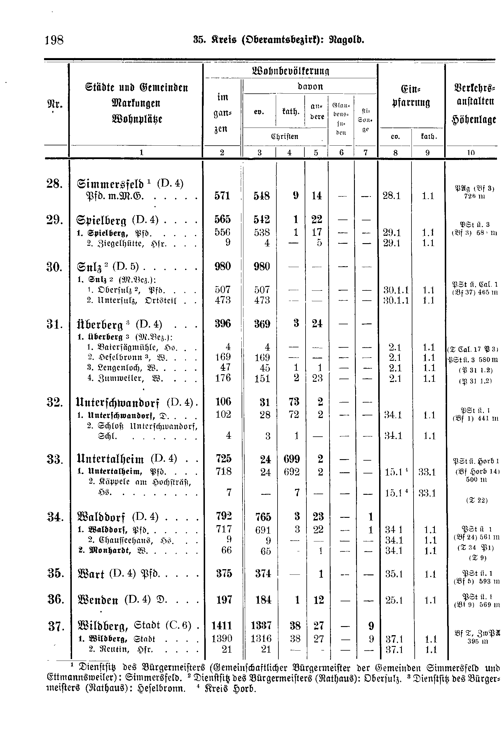
| Nr. | Stadtkreis Markungen Stadtteile |
Wohnbevölkerung | Einpfarrung | Verkehrs-anstalten Höhenlage | ||||||
|---|---|---|---|---|---|---|---|---|---|---|
| im ganzen | davon | |||||||||
| ev. | kath. | andere | Glau- bens- juden |
Son- stige | ||||||
| Christen | ev. | kath. | ||||||||
| 1 | 2 | 3 | 4 | 5 | 6 | 7 | 8 | 9 | 10 | |
| 28. | Simmersfeld[1] (D.4) Pfd. m. M.G. | 571 | 548 | 9 | 14 | - | - | 28.1 | 1.1 | PAg (Bf 3) 726m |
| 29. | Spielberg (D.4) | 565 | 542 | 1 | 22 | - | - | |||
| 1. Spielberg, Pfd. | 556 | 538 | 1 | 17 | - | 1 | 29.1 | 1.1 | PSt ü. 3 (Bf 3) 58?m | |
| 2. Ziegelhütte, Hsr. | 9 | 4 | - | 5 | - | - | 29.1 | 1.1 | ||
| 30. | Sulz[2] (D.5) | 980 | 980 | - | - | - | - | |||
| 1. Sulz[2] (M.Bez.): | ||||||||||
| 1. Obersulz[2], Pfd. | 507 | 507 | - | - | - | - | 30.1.1 | 1.1 | PSt ü. Cal. 1 (Bf 37) 465m | |
| 2. Untersulz, Ortsteil | 473 | 473 | - | - | - | - | 30.1.1 | 1.1 | ||
| 31. | Überberg[3] (D.4) | 396 | 369 | 3 | 24 | - | - | |||
| 1. Überberg[3] (M.Bez.): | ||||||||||
| 1. Baiersägmühle, Hs. | 4 | 4 | - | - | - | - | 2.1 | 1.1 | (T Cal. 17 P 3) | |
| 2. Heselbronn[3], W. | 169 | 169 | - | - | - | - | 2.1 | 1.1 | PSt ü. 3 580m | |
| 3. Lengenloch, W. | 47 | 45 | 1 | 1 | - | - | 2.1 | 1.1 | (P 31.1.2) | |
| 4. Zumweiler, W. | 176 | 151 | 2 | 23 | - | - | 2.1 | 1.1 | (P 31.1.2) | |
| 32. | Unterschwandorf (D.4) | 106 | 31 | 73 | 2 | - | - | |||
| 1. Unterschwandorf, D. | 102 | 28 | 72 | 2 | - | - | 34.1 | 1.1 | PSt ü. 1 (Bf 1) 441m | |
| 2. Schloß Unterschwandorf, Schl. | 4 | 3 | 1 | - | - | - | 34.1 | 1.1 | ||
| 33. | Untertalheim (D.4) | 725 | 24 | 699 | 2 | - | - | |||
| 1. Untertalheim, Pfd. | 718 | 24 | 692 | 2 | - | - | 15.1[4] | 33.1 | PSt ü. Horb 14 (Bf Horb 14) 500m | |
| 2. Käppele am Hochsträß, Hs. | 7 | - | 7 | - | - | - | 15.1[4] | 33.1 | ||
| 34. | Walddorf (D.4) | 792 | 765 | 3 | 23 | - | 1 | |||
| 1. Walddorf, Pfd. | 717 | 691 | 3 | 22 | - | 1 | 34.1 | 1.1 | PSt ü. 1 (Bf 24) 561m | |
| 2. Chausseehaus, Hs. | 9 | 9 | - | - | - | - | 34.1 | 1.1 | (T 34 P 1) | |
| 2. Monhardt, W. | 66 | 65 | - | 1 | - | - | 34.1 | 1.1 | (T 9) | |
| 35. | Wart (D.4) Pfd. | 375 | 374 | - | 1 | - | - | 35.1 | 1.1 | PSt ü. 1 (Bf 5) 593m |
| 36. | Wenden (D.4) D. | 197 | 184 | 1 | 12 | - | - | 25.1 | 1.1 | PSt ü. 1 (Bf 9) 569m |
| 37. | Wildberg Stadt (C.6) | 1411 | 1337 | 38 | 27 | - | 9 | |||
| 1. Wildberg, Stadt | 1390 | 1316 | 38 | 27 | - | 9 | 37.1 | 1.1 | Bf T, ZwPA 395m | |
| 2. Reutin, Hsr. | 21 | 21 | - | - | - | - | 37.1 | 1.1 | ||